Purpose: The
purpose of this lab is to gain experience using ESRI Arc Collector on our
phones, while gaining experience with geodatabase set up.
Data Collection: Using ESRI Arc Collector and our cellphones, we
walked out onto the UWEC campus to collect data points. We collected data
points on trash cans, light poles, parking signs, traffic signs, and university
signs. While collecting data points, we noted if they needed to be improved or
not. Before we went out onto campus, we set up domains for each feature to note
their feature type, owner, condition, and if they needed to be replaced (the
result of our domains is seen in figure 1).
 |
| Figure 1. The result of the domains we defined. This example was for a light post. |
Data Processing:
Once we collected all our data points using our phone, they were automatically
exported to the class lab 8 folder in ArcGIS Online and displayed as a point.
Results: The
results yielded the map in figure 2. All
the points are points we all collected, with each point either a light post,
trash can, parking sign, traffic sign, or university sign. With each point we
collected, we also noted the owner, condition, and if they feature needed to be
replaced.
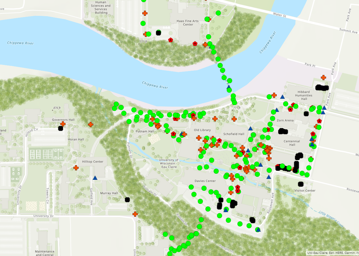 |
| Figure 2. Map of the data we collected. The green dots are light posts, the black squares are parking signs, the blue triangles are traffic control signs, the red pentagons are trash bins, and the orange crosses are university/general signs. |
Discussion: Using
ESRI ArcCollector was easy to use in my opinion. Once the domains are set it,
it is easy to walk to data points, and note the characteristics about them. In
my opinion, it is an effective surveying option because it of its
accessibility. I could see myself using ArcCollector out in the field if I was
collecting data like tree surveys, or the number of light poles to determine if
an area has enough lighting.
Regarding the map at figure 2, in looking at the attribute
table it seems that most of the points taken were light posts. There were 147
light posts out of 282 point features total. There were also 41 parking signs,
16 traffic signs, 22 trash bins, and 56 university signs. In analyzing the
attribute table, it seems most of the features are in fair to excellent
condition, only 32 features were stated to need replacing. The main indications
with this map are they is lots of lighting on campus (at least on lower campus)
given the number of light posts, however not a lot of trash bins.
It seems there isn’t a spatial pattern for light
posts, other than being anywhere where there is a street or a walk path.
University signs and trash bins seem to be closer to buildings, which makes
sense given the signs are usually identifying the building they’re in front of,
and trash bins are for the people who are entering and exiting the buildings.
Parking signs are generally in parking lots, and traffic signs are generally by
roads, which makes sense given the nature of those signs.
No comments:
Post a Comment